
AI Hillside and Slope Garden Design: How Technology Solves the Hardest Landscaping Problems
Winnie Astrid
Garden Design Editor
A sloped yard is the problem most AI design tools quietly give up on. They treat every photo as flat ground, apply a style layer on top, and return a render that looks nothing like the actual hillside you uploaded. Drainage disappears. Terracing is impossible. The result is a pretty image of a garden that could never exist on your property. Here is how purpose-built spatial AI handles what generic tools cannot — and how to get the most accurate renders from a site with real gradient.
Why Slopes Confuse Standard AI Design Tools
Standard AI landscape design tools are built around a simple assumption: the yard is flat. That assumption is embedded at every layer of the pipeline — from how the image is preprocessed, to how style is applied, to what the output render looks like. When you upload a photo of a sloped site, the tool flattens it. The gradient disappears. Retaining walls are ignored or rendered as decorative elements floating at the wrong depth. Terraces appear as flat bands rather than as engineered structures with correct footing and drainage logic.
Generic image generators are the worst offenders. They have no spatial understanding at all — they apply a texture to the 2D projection of your photo and call it a design. Upload a steep hillside and you receive a render showing a flat lawn with a view behind it. The slope has been visually erased. The result looks like a different property entirely.
The second problem is drainage. A sloped yard has drainage implications that directly affect plant selection, hardscaping choices, and structural requirements. A flat-ground AI tool has no concept of water flow, gradient, or soil saturation. It will confidently suggest moisture-sensitive species for the base of a slope where runoff accumulates, or recommend gravel hardscaping without accounting for the erosion that gravel accelerates on a gradient above 15 degrees.
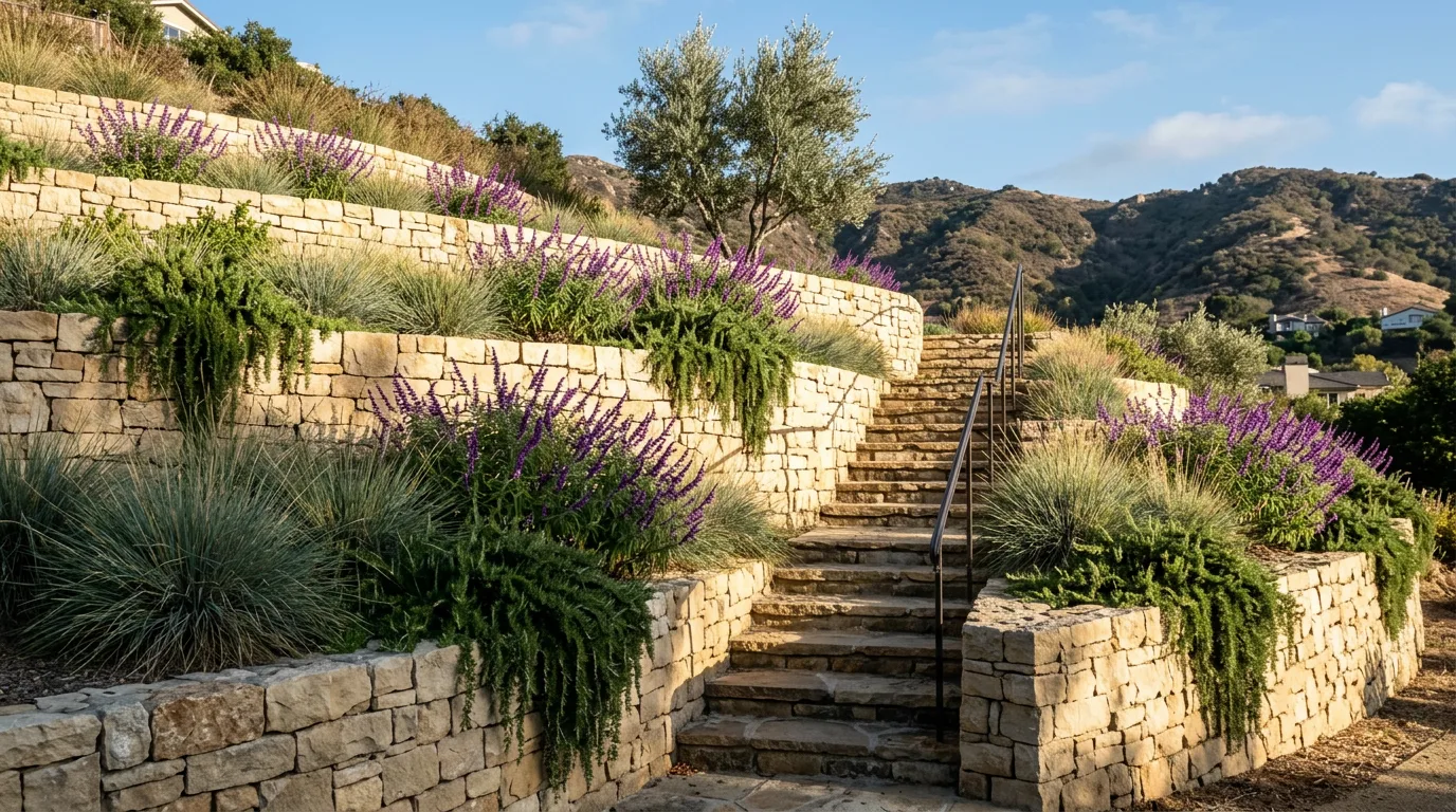
The third problem is terracing. Any sloped site with a gradient above roughly 10–12 degrees typically benefits from terracing — flat planting beds carved into the slope and retained by walls or edging. Standard AI tools cannot generate terraced configurations from a photo because they have no model of the terrain beneath the surface. They see pixels, not depth.
The core gap
- Generic AI: applies style to a 2D projection — the slope becomes invisible
- Generic AI: no drainage or gradient awareness — plant suggestions ignore slope dynamics
- Generic AI: cannot generate terraced configurations because there is no terrain model
How Hadaa’s Spatial Pipeline Approaches Slopes Differently
Hadaa’s engine begins with a scene understanding pass before any style is applied. This pass reads depth cues from the photo — perspective convergence, shadow angles, surface texture changes, and edge geometry — to build a spatial model of the site. On a sloped yard, this spatial model captures the terrain gradient rather than collapsing it into a flat plane.
That terrain model is what allows the engine to render retaining walls at the correct depth, place terraced planting at accurate grades, and avoid applying flat-ground planting patterns to a site that cannot support them. The render reflects the actual geometry of your hillside, not an idealized flat substitution.
The most accurate results on a sloped site come from the Change Viewpoint engine. Upload 4–14 photos of the slope from different positions — uphill looking down, downhill looking up, left and right boundaries, any retaining structures or existing terraces — and the engine synthesizes an overhead aerial map of the entire slope. That aerial view is the most honest representation of sloped terrain available from standard photo inputs: it removes the perspective distortion that makes a slope look either steeper or shallower than it is in a single ground-level shot.
Design on the aerial map using Style Presets or Smart Fix, then transfer the finished design to any of your original ground-level photos. You get the spatial accuracy of a bird’s-eye plan with the visual impact of a photorealistic ground-level render.
Change Viewpoint on a sloped site
-
1
Upload 4–14 photos from uphill, downhill, and both boundaries
More angles = more accurate terrain model. The aerial synthesis reads the gradient from overlap between shots.
-
2
Review the synthesized aerial map
The overhead view shows the slope as a contour you can design on — not distorted by a single ground-level perspective.
-
3
Design on the map with Smart Fix or Style Presets
Specify retaining walls, terrace positions, and plant zones on the flat aerial canvas where placement is precise.
-
4
Transfer to any ground-level photo
The finished design renders back into your original photos at the correct depth and perspective for each viewpoint.
Retaining Walls and Terracing: What AI Can Visualize
Retaining walls are the defining structural element of any sloped garden design. They hold terraced planting levels in place, control erosion, and create the flat surfaces where usable garden space is possible on a gradient. Visualizing different wall configurations before committing to construction costs is exactly where AI design adds direct financial value.
Use Hadaa’s Smart Fix engine to specify retaining wall materials and configurations in plain language. The engine reads spatial instructions — left boundary, lower third of the slope, along the path edge — and places the wall into the scene at the correct depth and perspective. Effective Smart Fix prompts for retaining walls include:
Example Smart Fix prompts for slope design
- “Add a stacked stone retaining wall along the lower boundary with a planted bed above it.”
- “Create three terraced levels on the slope separated by low timber retaining walls, each with a planting bed.”
- “Replace the steep lawn with two flat terraces separated by a dry-stack limestone retaining wall and steps between them.”
- “Add a gabion wire-basket retaining wall along the right slope boundary with ornamental grasses at the base.”
You can preview multiple wall materials in separate Smart Fix runs — stacked stone, dry-stack limestone, timber sleepers, poured concrete, gabion baskets — and compare the visual results before speaking to a contractor. This is the part of the design process where AI delivers the most immediate value on a sloped site: seeing a $15,000 construction decision rendered at full quality before any ground is broken.
What AI cannot replace: structural engineering decisions about retaining wall footings, drainage pipe placement, backfill compaction specifications, and load-bearing calculations. A wall over 3–4 feet tall on a loaded slope almost always requires a structural engineer’s sign-off, and that is the correct professional for those decisions. Use Hadaa to visualize and communicate what you want — then engage a qualified contractor or structural engineer to specify how to build it safely.
Verdict on retaining wall visualization
Smart Fix handles material selection and basic terrace configuration well. For sites with significant gradient or walls above waist height, treat the AI render as the brief you hand to an engineer — not the engineering specification itself.
Plants for Sloped Sites: Erosion Control and Slope-Tolerant Species
Plant selection on a slope is a functional decision before it is an aesthetic one. The wrong plants on a gradient accelerate erosion, fail to establish root systems deep enough to hold soil, or suffer from the drainage extremes that characterize sloped ground — saturated at the base, bone-dry at the top.
Hadaa’s Biological Engine applies USDA hardiness zone verification to every plant recommendation, including slope-specific species. But the slope factor matters independently of zone: a plant that thrives in Zone 7 flat ground may still be wrong for a Zone 7 hillside if it has shallow roots or poor drought tolerance. The categories below reflect both dimensions.
Erosion Control Groundcovers
Fast-establishing, dense-rooting groundcovers are the first line of defence on bare or thinly planted slopes. These species prioritize root depth and lateral spread over visual statement — but many are also genuinely attractive.
- Creeping juniper (Juniperus horizontalis) — deep-rooting, drought-tolerant, Zones 3–9. Spreads to cover large areas with minimal maintenance.
- Crown vetch (Coronilla varia) — aggressive spreader ideal for stabilizing steep slopes. Zone 3–9. Use with intent — it outcompetes other groundcovers.
- Cotoneaster horizontalis — low, spreading habit with excellent slope adhesion, seasonal berries, and autumn colour. Zones 5–8.
- Native sedges (Carex spp.) — fibrous root systems that bind soil effectively. Shade- and moisture-tolerant; excellent for slope bases with seasonal water.
Ornamental Grasses That Hold Soil
Ornamental grasses combine the erosion-control function of deep fibrous roots with the visual impact of year-round movement and structure. They are among the most effective slope plants available for mild to moderate gradients.
- Miscanthus sinensis (maiden grass) — tall, dramatic, fibrous root system. Zones 4–9. Excellent on mid-slope for visual structure and soil retention.
- Panicum virgatum (switchgrass) — deep-rooting native, exceptional drought tolerance. Zones 5–9. Self-seeding on established slopes.
- Festuca glauca (blue fescue) — low-growing, compact, striking blue foliage. Zones 4–8. Ideal for front-of-border slope planting where visual detail matters.
Flowering Slope-Tolerant Perennials
Once erosion control is established, flowering perennials bring seasonal interest without destabilizing the slope. These species are drought-tolerant in the upper layers and robust enough to establish on a gradient.
- Hemerocallis (daylily) — widely adapted Zones 3–9, tolerates poor soils, spreads to form a dense weed-suppressing mat.
- Nepeta (catmint) — drought-tolerant, aromatic, self-seeds on slopes. Zones 3–8. Excellent mid-slope filler with long flower period.
- Ceanothus (California lilac) — deep-rooting, nitrogen-fixing native. Zones 7–10. Outstanding on dry west-facing slopes. Not for cold, wet sites.
Zone verification matters more on slopes
A slope amplifies climate extremes: the top drains faster and dries out sooner; the base accumulates water and stays wet longer. Hadaa’s Biological Engine cross-references your USDA zone against each plant’s drainage and moisture tolerance — not just temperature range. This is why the engine’s plant recommendations for a sloped site in Zone 6 look different from those for a flat Zone 6 garden. See how Hadaa’s zone verification works →
Why Aerial Synthesis Is Especially Valuable for Sloped Gardens
Ground-level photography of a sloped garden is inherently misleading. Shoot uphill and the slope appears gentle — foreshortening compresses the gradient. Shoot downhill and it looks steep — perspective exaggerates the drop. Neither view gives you an accurate sense of the actual area available for planting, the relative positions of different levels, or where retaining walls fall in relation to boundaries and paths.
The aerial view removes all of this distortion. Looking straight down at a sloped site, you see the actual footprint: where each terrace level sits, how wide the planting beds are, where the retaining walls run, and how the whole slope relates to the boundary fence and the house. This is the view professional landscape architects use when drawing site plans precisely because it is the only view that does not lie about area or position.
Hadaa’s Change Viewpoint engine synthesizes this aerial view from your uploaded ground-level photos — no drone required. Upload 4–14 photos of the slope from different positions, choose the overhead map as your engine, and you have a design canvas that accurately represents your terrain. Design the terracing, planting, and hardscaping on that overhead canvas. Then transfer the finished design back to any of your original ground-level photos for a photorealistic render at eye level.
The sequence — design in aerial, render at ground level — is the most accurate workflow available for sloped sites with standard consumer photo inputs. It combines the spatial accuracy of a professional plan with the visual impact of a photorealistic perspective render.
4–12
photos to build the aerial map
0°
perspective distortion in the aerial view
Any angle
transfer to any original ground-level photo
5 Practical Tips for Better AI Renders on a Sloped Site
Sloped sites demand a slightly different shooting and prompting approach than flat yards. These five techniques consistently produce more accurate renders and more useful designs from hillside photos.
Shoot from both uphill and downhill
A single shot from one end of the slope gives the AI an incomplete terrain model. Two shots from opposite ends — one looking up, one looking down — let the engine triangulate the actual gradient. Include these as part of your 4–14 photo upload for Change Viewpoint aerial synthesis. The uphill shot is especially important: it shows the full slope face, retaining structures, and the relationship between levels.
Include a reference object for scale
Slopes are deceptive in photos. A fence post of known height, a person standing at mid-slope, or a garden fork pushed into the ground gives the engine a scale reference it can use to accurately size retaining walls, terrace heights, and planting areas. Without scale reference, a Smart Fix prompt for a '3-foot retaining wall' may produce a wall that looks proportionally correct but is visually the wrong size for your actual site.
Describe the gradient in your Smart Fix prompt
The engine responds to spatial specificity. 'The slope drops approximately 8 feet from the top boundary to the lower path' gives the engine more to work with than 'sloped garden.' Include the approximate fall, the direction (north-facing, south-facing), and whether there are any existing structures mid-slope. More context = more accurate placement of terraces, steps, and retaining features.
Use masking to protect existing retaining structures
If your slope already has retaining walls, existing terraces, or established planting you want to keep, use Hadaa's Masking Brush to mark those elements before running any design. This tells the engine what not to change. Sloped sites often have significant sunk-cost infrastructure — a concrete block wall, a decades-old terrace — that would be expensive to replace. Masking preserves it while allowing the engine to redesign the planted areas around it.
Review the aerial map before designing
After Change Viewpoint synthesizes the aerial map of your slope, spend a moment verifying that it accurately represents your site layout before committing to a design direction. Check that terrace positions, boundary lines, and existing structures are correctly placed. A minor correction to the aerial map before designing saves re-running the entire pipeline after. Accurate aerial canvas = accurate ground-level render.
Frequently Asked Questions
Can AI design tools handle sloped and hillside gardens?
How do I design a terraced garden with AI?
What plants work best on a slope?
Does Hadaa work for drainage and retaining wall planning?
How do I get an accurate render of my sloped backyard?
AI Slope Garden Design — Hadaa
Your slope isn’t a problem. It’s a design opportunity.
Upload photos of your hillside from uphill and downhill. Hadaa’s spatial pipeline reads the terrain, generates retaining wall and terrace options, and applies zone-verified planting — all before you move a single stone.


